
Somewhere in the Peruvian Andes, a stone path winds through misty cloud forests, climbs high above the treeline, and ends at one of the most celebrated ancient cities on Earth. The Inca Trail is not just a hike — it is a four-day walk through living history. Every step leads deeper into a world the Inca people built over five centuries ago. For those who take it on, the trail offers something greater than a workout: a journey that changes how you see the world.
A Path Built for Something Sacred
The Inca Trail stretches 42 kilometers (about 26 miles) through the mountains of the Cusco region in Peru (source). It forms one part of the Qhapaq Ñan — a massive Inca road system that once connected territories spanning what are now Colombia, Ecuador, Peru, Bolivia, Chile, and Argentina (source). In the mid-1400s, under Inca ruler Pachacútec Yupanqui, workers carved this particular route into the Andean landscape not for trade or military movement, but as a ceremonial path leading to the sanctuary of Machu Picchu (source).
Unlike much of the broader road network, which served practical and political functions, the route to Machu Picchu was reserved for priests and members of the Inca elite who made the journey as a spiritual pilgrimage (source). American explorer Hiram Bingham III reached Machu Picchu in 1911 and later uncovered much of the overgrown trail while exploring the surrounding area in 1915 (source). Restoration work by the Peruvian government in the late 1990s consolidated the route into the world-class trek that draws visitors from around the globe today (source).
The Day That Tests Your Legs — And Your Lungs
Most hikers complete the Classic Inca Trail over four days. The route begins near the Urubamba River and climbs through wildly different landscapes before arriving at Machu Picchu. The first day is a relatively gentle introduction — a steady walk through river valleys and early ruins that helps the body adjust to the altitude. The second day, however, is a completely different story.
Day two brings hikers face to face with the trail's most demanding and highest point — a mountain pass called Warmiwañusca, widely known in English as Dead Woman's Pass. At 4,215 meters (13,828 feet) above sea level, it rises nearly 1,800 meters (5,905 feet) higher than Machu Picchu itself (source). The pass gets its name from the mountain's shape: when viewed from the valley below, the ridgeline looks like the silhouette of a woman lying on her back (source). The air at the top is thin, the climb relentless, and the weather can turn quickly from bright sun to biting wind. Reaching the summit — exhausted, breathless, and looking out over ridges that seem to go on forever — is a moment hikers talk about for years.
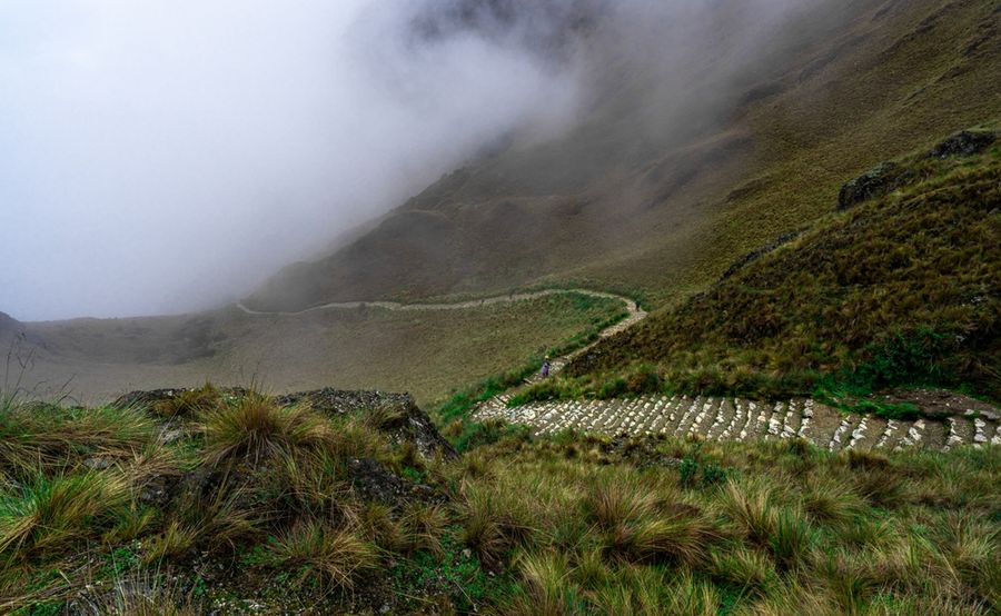
A Living World Along the Way
One of the biggest surprises for first-time hikers is just how rich the trail is with plant life. The lower sections pass through a lush cloud forest, where thick mosses coat every branch and the air stays cool and damp year-round. This environment supports more than 400 species of orchids, many of which grow nowhere else on Earth (source). Among the most striking plants found at higher elevations is the Polylepis tree — one of the highest-growing tree species anywhere in the world — recognized by its peeling, reddish bark that gives it an ancient, almost mysterious look (source).
Wildlife is everywhere for those who slow down and pay attention. The Andean Cock-of-the-Rock, Peru's national bird, flashes through the forest with its brilliant red-orange feathers, while dozens of hummingbird species dart between blooms. The spectacled bear — the only bear native to South America — also roams these mountains, named for the pale rings around its eyes that resemble a pair of eyeglasses (source). Higher up on the trail, the Andean deer moves quietly through open grasslands. The best time to see both wildlife and flowering orchids is during the dry season, which runs from April through October.³
Planning Ahead: The Permit System
Booking the Inca Trail requires planning well in advance. To protect both the fragile Andean ecosystem and the ancient stone paths themselves, Peru's government caps daily access at 500 people — a total that includes mandatory guides and porters (source). The trail also closes entirely each February for maintenance and recovery, removing that month from consideration entirely (source).
Because of these strict limits, permits for the most popular months — June, July, and August — can sell out many months in advance. All permits are linked to individual passport numbers and are non-transferable — and they must be secured through a licensed tour operator, as the trail cannot be hiked independently (source). This system exists to prevent the kind of heavy, unmanaged foot traffic that would otherwise cause lasting damage to irreplaceable archaeological sites and the mountain environment around them.
Where the Mountain Finally Opens Up
After three days of climbing, descending, and moving through some of the most extraordinary terrain on the continent, the final morning starts well before sunrise. Hikers leave their last campsite in the dark and make their way along the closing stretch of stone path toward a gateway called Inti Punku — the Quechua name for "Sun Gate." Built by the Inca in the 15th century, Inti Punku was deliberately aligned with the rising sun during the June solstice, so that the gateway would frame the morning light in a way that felt sacred and intentional to those arriving (source).
Reaching the Sun Gate as daylight breaks over the mountains is widely considered the emotional peak of the entire trek. Through the stone gateway's frame, Machu Picchu comes into view for the first time — its terraces, temples, and towers spread across a narrow mountain ridge, wrapped in morning cloud and surrounded by green peaks falling steeply into the valley far below.¹ It is a view that no photograph fully prepares a person for. And it is one that most hikers carry with them long after Peru is far behind.